MSMM Engineering, LLC

Our Projects

Explore our portfolio of engineering projects across the Gulf South

PUA & ACUD #1 Water Meter Replacements
Water & Wastewater|In Progress

PUA & ACUD #1 Water Meter Replacements

Through a Federal program to fund Environmental Infrastructure programs within local municipalities, MSMM representing the USACE New Orleans District, is working with the Ascension Parish Government (non-Federal sponsor) to prepare plans and specifications for a water meter replacement program in the Donaldsonville area of Ascension Parish. With many of the water meters in this area being manually read meters and well beyond their design life, it was determined to be a valuable project for the parish to not only reduce labor costs but increase revenues since it was estimated the old water meters were under reporting usage by as much as 30% of water used. MSMM was responsible for providing 100% bid ready plans and specifications (in USACE format) for removal and replacement of approximately 3,500 water meters of various sizes and installation of four fixed location data collection devices to be mounted on water towers located in the project area. Meter removal and replacement included new meter boxes, meters, encoder registers and antenna; traffic control; and removal and replacement of asphalt/concrete driveways and sidewalks. In order to have the new water meters and data collection devices work seamlessly with the other areas of the Ascension Parish water system, data collection and billing software, MSMM prepared a J&A document (Justification for other than full and open competition) to allow the use of sole source product. Additional services performed or to be performed by MSMM included field work, obtaining X-Y coordinates for all meter locations, MCACES cost estimate, coordination with Ascension Parish and agencies having jurisdiction, preparation of Letter Report for Project Partnership Agreement between USACE and Ascension Parish, and assistance the USACE with EA, bidding and construction services.

Ascension Parish, LA

Bayou Segnette State Park Improvements
Public Infrastructure|2024|Completed

Bayou Segnette State Park Improvements

The project consists of five (5) areas of work, including playground improvements, boat launch improvements, culvert replacement, cabin roadway improvements, and bridge improvements. Implementation of the project was required as sea level rise and lack of routine maintenance had left a portion of the State Park unusable to the public. The design team was tasked with complete engineering services inclusive of topographic survey, preparation of a full design package, including drawings and specifications, coordination with the client for bidding, construction administration, and resident inspection services for all areas of work. The playground and boat launch components were designed as stand-alone construction packages, and each construction package was released for bid 3-4 months apart to stagger the construction area. Our design team strategically designed and released the construction packages to ensure multiple contractors could work in the area at the same time, and to ensure that all available construction funding was utilized. The playground scope included re-grading of the site for ADA access, use of poured-in-place rubberized play surface for the playground fall zone, and installation of new sidewalks and miscellaneous drainage improvements. The playground was the first project released for bid and the first project constructed. The boat launch scope included making improvements to the existing launch area and overflow parking lot due to constant flooding. The work consists of cold milling the existing asphalt surface in the boat launch area, adding a new asphalt surface at a higher elevation, removing the existing site lighting, and replacing with an LED lighting system, adding a covered structure and walkway to dock for adverse weather conditions, adding a trench drain system to convey storm runoff, and adding new sidewalks and curbing. The overflow parking lot consists of adding asphalt to the existing asphalt surface to raise its elevation. Boat launch work includes new piling and setting a new elevation for the launch to be equivalent with the parking lot elevation. The culvert replacement, cabin roadway improvements and bridge approach replacements were designed but not constructed due to funding limitations. The current conditions were such that during high tide, and dependent on wind direction, the cabin roadway was completely inundated and unpassable, leading the public to not have access to the cabins. The design elevated the entire roadway, sidewalks, utility maintenance pads, and parking areas for the cabins. Following construction, high tide would no longer engulf the roadway and would allow the public to access the cabins without delay. The culvert replacement design removed and replaced numerous cross culverts which had severe settlement issues. Additionally, the bridge approaches had to be re-designed due to settlement issues. MSMM is the Prime firm for this project and was tasked with providing 100% of the design and construction services associated with this project.

Westwego, LA

Blue and Green Corridors Stormwater Resilience
Ecosystem Restoration|2021|Completed

Blue and Green Corridors Stormwater Resilience

MSMM Engineering, a DBE subconsultant to Stantec, performed electrical design and Entergy coordination on Phase I and Phase 3 of the Blue and Green Corridors Stormwater Resilience Project in Gentilly. The phase I project is to create canals (blue corridors) and vegetation/parks (green corridors) within the neutral grounds on Robert E. Lee Boulevard between London Drive and Franklin Avenue, and on Elysian Fields Avenue between Filmore Avenue and Robert E. Lee Boulevard. MSMM’s design tasks were to design site lighting and provide power to bridge accent lighting, two pump stations, multiple pedestrian countdowns, aeration tubing, three aeration fountains and three submersible waterfall pumps. Coordination was required with the design team and the City of New Orleans staff to identify the correct location for these features. The phase 3 project provides blue and green infrastructure at the northeast and northwest corners of Robert E. Lee Boulevard and St. Anthony Avenue and all four corners at the intersection of Robert E. Lee Boulevard and St. Roch Avenue. MSMM is tasked with designing site lighting and project programming. Both phases required extensive knowledge of the Green Infrastructure features being designed, the overall purpose/objective of the project, extensive coordination with stakeholders and public utility design to City of New Orleans standards. The anticipated completion date for this project is June 2021.

Gentilly, New Orleans, LA

Bourbon Street Resident Inspection
Public Infrastructure|2017|Completed

Bourbon Street Resident Inspection

MSMM is currently under contract with team member Mott MacDonald to perform resident inspection services for the Bourbon Street project currently under construction. As part of this contract, MSMM has two resident inspectors managing up to three crews working 6-7 days per week. The project is being constructed as a design-build project, thus MSMM inspectors are expected to prepare and submit field reports on a daily basis to the City of New Orleans Department of Public Works and Mott MacDonald engineers. In addition to field reporting on a daily basis, MSMM inspectors work in collaboration with Mott MacDonald engineering staff to identify any unknown field conditions and report update project plans on a block by block basis. The project started at the end of April and is expected to be completed by the end of 2017.

New Orleans, LA

Calcasieu Ship Channel Salinity Control
Ecosystem Restoration|In Progress

Calcasieu Ship Channel Salinity Control

MSMM is working to deliver salinity control measures to marshes located near the Calcasieu Ship Channel in southwestern Louisiana. The overall Calcasieu Ship Channel Salinity Control project is managed by the client, the Coastal Protection and Restoration Authority (CPRA) of Louisiana. This project proposes the development of a project to manage salinity in order to reduce the rate of wetland loss within the Calcasieu-Sabine watershed region. The project aims to address long-term sustainability, while considering the economic needs of the region. The concept solution is a large-scale tide gate across the mouth of the Calcasieu Ship Channel; solutions to be analyzed include a variety of hydraulic and coastal structures. MSMM is currently designing two features of this project. The two projects designed by MSMM consist of the West Pass and Joe’s Cut project features. As part of developing these features, MSMM is responsible for project management, topographic, bathymetric, and magnetometer surveys; geotechnical data collection and engineering; collection and reporting in support of regulatory compliance, landowner notification/ROW drawings and complete engineering design of the salinity control and shoreline protection measures. Following the initial survey and geotechnical investigations, the MSMM engineering team decided that the best alternative for this project to meet the restoration goals would be to construct combi-walls (combination of pipe piles and sheet piling). The design of the West Pass and Joe’s cut Combi walls, a distance of roughly 3,000 feet, is currently progressing and preliminary submittals have been made. It is anticipated that this project will be bid ready in the spring if 2020.

Calcasieu Parish, LA

Causeway Boulevard and Scott Street Sewer Lift Station
Water & Wastewater|2022|Completed

Causeway Boulevard and Scott Street Sewer Lift Station

MSMM was tasked by the Jefferson Parish Department of Sewerage to provide full engineering design for sewer lift station rehabilitation to the Causeway and Scott Sewer Lift Station located in Metairie, LA. The existing Scott Street lift station is a submersible pump station with a buried fiberglass wetwell containing three pumps and a buried fiberglass valve pit. The 10” pipes on each pump combine to discharge into a 16-inch diameter pipe that goes to the Shresbury & Railroad lift station. The lift station required replacement of pumps, piping, valves, controls and other rehabilitation items including elevating the top slab to mitigate floodwaters entering the wetwell. MSMM tasks on this project consisted of full engineering and design for rehabilitation of this this station. This included: replacing the pumps, replacing the control panel, replacing discharge piping and valves, designing a method to elevate the access hatch into the wetwell and valve pit, repaving the area surrounding the lift station to assist with drainage, adding an emergency pump out (EPO) manhole and adding odor control. MSMM completed full engineering and design in mid-2019. Construction was completed in mid-2022.

Metairie, LA

Chitimacha Tribe Sanitary Sewer Data Collection
Database/GIS Mapping|2022|Completed

Chitimacha Tribe Sanitary Sewer Data Collection

MSMM Engineering, LLC assisted the Sovereign Nation of the Chitimacha Tribe of Charenton, LA with advancing an ongoing Foundational GIS initiative they have been pursuing to advance sewer infrastructure goals developed for their Tribal lands. Under the Flood Plain Management Services (FPMS) program, MSMM staff undertook a planning initiative that involved completing an assessment of the current sewer infrastructure on-site, cataloging the existing information, and developing CAD and GIS data sets for the Tribe to use in future infrastructure planning. MSMM initiated these efforts by hosting various meetings with Chitimacha Tribal leadership and Tribal community leaders to gain an understanding of the public infrastructure issues the tribe was facing. With this information in mind, field assessments and aerial imagery were used as planning tools to provide existing condition assessments of the Tribal lands. The first task that MSMM undertook was to create CAD sheets and GIS drawings for the existing sewer system, and to create CAD sheets for the planned sewer upgrades. Through the process of creating these databases, MSMM was able to incorporate all as-built drawings into the GIS and CAD databases and incorporate attribute features that the Tribe requested to be included, including manhole locations, numbers, department, and pipe size. Through the end of MSMM’s efforts working through the FPMS program, MSMM was able to create an upward reporting tool that is available to the not only the Tribe but the New Orleans District. In addition, LIDAR was flown to provide aerial photography of the Tribe lands, and all existing and future project conditions, along with future infrastructure recommendations were provided to the Chitimacha Tribe leadership.

Charenton, LA

Coventry Court Drainage Evaluation and Subsurface Design
H & H Modeling|2018|Completed

Coventry Court Drainage Evaluation and Subsurface Design

In early 2017, and following repetitive street flooding in the Coventry Court area of River Ridge, MSMM Engineering worked with the Jefferson Parish District 2 office to propose a solution to the flooding issues in the area. The MSMM engineering team identified several potential options that could be evaluated, and in 2018 the Jefferson Parish Council tasked our staff with developing a multi-phase feasibility report to evaluate several drainage solutions in the area. As part of the Coventry Court evaluation, the Jefferson Parish drainage department requested that MSMM investigate and determine the feasibility of providing improved drainage. The investigation consisted of the following: – Evaluation Phase/Data Review – collection and analysis of existing information – Field Reconnaissance and Preliminary Survey – collection of relevant field information – Model Runs and Calibration – updated the HEC-RAS model with the area’s data for 10-year, 50-year and 100-year storm events. – Cost Estimating of Multiple Alternatives – provided detailed cost breakouts consisting of vendor furnished pricing data for materials – Development of a Prioritized List of Recommendations The final report was completed in less than 6 months, and the final recommendation is to design a new drainage pump station on a vacant parcel owned by the parish between Coventry Court and Lee Court, westerly of Jefferson Highway. This 90 cfs (120 cfs ultimate) pump station with a 48’ open cut discharge forcemain placed down Colonial Heights Road and over the Mississippi River levee. Other project features consist of a discharge dolphin in the Mississippi River and upsizing of the Jefferson Highway drainage crossings and downstream conveyance. This recommended alternative provides the greatest pumping capacity while requiring the least amount of permanent drainage servitudes. MSMM was also selected to provide subsurface drainage design phase of the Coventry Court project. For this component of the project, our civil and structural engineers are currently designing 500 linear feet of 48” RCP drain pipe from Rex to Hazel Street, 1,100 linear feet of 54” RCP drain pipe from Hazel to Colonial Heights, and 200 linear feet of 72’ RCP drain pipe from Jefferson Highway to the proposed site of the drainage pump station. This drainage design was the first step in the Coventry Court drainage pump station process, and allowed the project to move forward as utility conflicts and permitting for this phase.

River Ridge, LA

Cow Bayou Drainage Pump Station Complex
Flood Control|In Progress

Cow Bayou Drainage Pump Station Complex

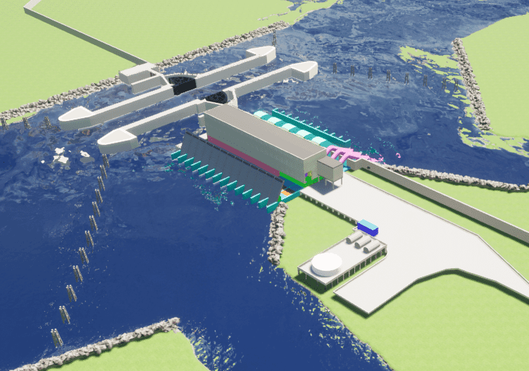
Our team completed 35% design of the 8,190 CFS pump station as part of the Sabine to Galveston Cow Bayou Complex project. The Cow Bayou Complex includes levee tie-ins, floodwalls, sluice gate structures and a sector gate for navigational traffic. The pump station consists of five 1,365 CFS horizontal, vacuum primed pumps requiring 126-inch suction side and 115-inch discharge side with formed concrete intakes; and three 455 CFS vertical self-priming pumps with 84-inch discharge piping. The preliminary design phase was a joint engineering effort between USACE New Orleans District, Galveston District and our team in which we operate as a one integrated design team. Our design responsibility included structural design, architectural design, civil site work, geotechnical evaluation and design, MII cost estimating, CAD drafting and project management. A unique feature of this project design is that we are an integrated design team with the New Orleans District who is providing the mechanical and electrical design while we are responsible for coordinating the mechanical and electrical design with the civil, structural and geotechnical engineering design. Other project features being designed by our team include dolphin structures which protect the facility above the water level from possible boat impact, a pump station safe house, and a fuel farm and access roads. We designed the project in Microstation 3D, also utilizing Revit BIM 3D modeling for the facilities. Preliminary investigations consisted of extensive geotechnical testing to determine soil suitability, preliminary estimates of dredging based on navigational traffic loads in the Cow Bayou area, and structural calculations to determine the required height of the T-walls, and navigational structures. Preliminary architectural work was also completed to design the safe house that is attached to the main pump station building. The safe house includes all facilities and work spaces for the pump station operators. The pump station reinforced concrete structure is 250 FT wide by 128 FT long with 8 pump bays and supported by 100 FT long steel H-pile. The vertical pumps, engines, generators, gear boxes, vacuum pumps and electrical equipment are all housed within the pump station building. The structural steel building located above the concrete pump station structure is 43 FT tall and utilizes 8 IN thick precast concrete tilt up wall panels on all four sides of the building. The roof consists of 6 IN concrete slab on metal roof deck attached to the supporting members maintaining a 1:12 slope. All of these features were designed by our engineers and architects. Our structural engineers, following USACE engineering manuals, designed all permanent project structures associated with the pump station including the horizontal and vertical pump intake and discharge structures, engine and pump support slabs, pump station building, pump station safe house, fuel tank foundation and containment area, water tank foundation, west access bridge, exterior semi-gantry and overhead bridge crane supports, as well as the protective dolphins on the intake and discharge side of the pump station. The pump station and safe house were designed utilizing STAAD software (a 3D structural analysis and design software). Our engineers also reviewed preliminary hydrologic and hydraulic modeling results for the area to set the appropriate protection elevations for all of the risk reduction measures developed as part of this project. The pump station safe house is a two-story structure 36 FT long by 22 FT wide. The building is supported by cast-in place concrete beams and cast-in place concrete columns. The safe house is a separate structure but abuts to the pump station building. The safe house provides housing for four to six emergency personnel that shall be required to man the facility during a hurricane, and it is designed for tornado force winds. The safe house required a 1,000 gallon per day onsite wastewater treatment facility due to the lack of facilities in the project area. Our civil engineering team provided the wastewater treatment facility design. The pump station fuel farm consists of an elevated concrete platform structure with containment walls designed to support the three 16K GAL fuel tanks for the pump station. Adjacent to the fuel farm a 55K GAL above ground water storage tank was included as a backup water supply. The sizing was based on providing emergency water for safe house occupants, pump bearing lubrication and safe house sprinkler operations in the event of an emergency. The geotechnical services included engineering analyses on the soil borings data in which the New Orleans District provided our geotechnical engineers. The team provided recommendations regarding site preparation and drainage, estimates of allowable pile load capacity for support of pump station components and the fuel platform, and estimates of settlement. The geotechnical analysis included performing deep seated stability analyses of the pump station, determining the unbalanced force on the pump station, designing seepage cutoff beneath the pump station, performing analyses to evaluate potential uplift of the pump station during and after construction, determining lateral earth pressures for the wall design, and providing a preliminary design for temporary retaining structures (TRS) to construct the pump station. Analyses were also performed for the design of the dolphins to protect the pump station and gates. As part of our project management activities and coordination between our design team and the USACE mechanical/electrical design team, we prepared a detailed communication plan which outlined procedures for coordination of design activities and the transfer of information between all parties. The plan addressed scheduling, communication distribution structure, information collection and filing procedures, and a flow chart of personnel and project progression. Our team was responsible for combing the design data for each submittal in which we incorporated the USACE-prepared plans, specs and DDR write-ups into our deliverable set. We also prepared the MII cost estimate for the 35% design package. Following receipt of the 35% design package, SWD has engaged CERL/ERDC to complete additional hydrologic and hydraulic modeling and changing the acquisition strategy to Design-Build. Currently, our team is awaiting ERDC to complete updated modeling in order to finalize the design package into a Design-Build RFP package which will occur under a future task order

Orange, TX

CWPPRA Program Scanning, Digitizing, and Document Control System
Database/GIS Mapping|2011|Completed

CWPPRA Program Scanning, Digitizing, and Document Control System

Inventory analysis, need assessment, archive and index Coastal Westland Planning, Protection and Restoration Act (CWPPRA) documents Scanning, digitization, document control system Create database, supply and utilize software for search and retrieval of documents Prepare 21st Priority Project List (PPL) report for CWPPRA Management support for modeling projects, FEMA mapping and modeling documentation QA/QC Project management. This project is primarily based on CWPPRA’s critical need for archiving, storing, and retaining the documents, drawings, maps and artifacts under one centralized system. As well, the 21st PPL report is prepared following guidance provided by the Coastal Wetlands Planning, Protection, and Restoration Act, Public Law 101-646, title III, Section 303, and in accordance with direction from the US Army Corps of Engineers (USACE), New Orleans District (CEMVN). The report is to contain project descriptions, environmental benefit determinations, cost estimates, general supporting information, overviews of the study authority, program capacity, study process and plan formulation. Project Tasks: CWPPRA documentation, digitization, archiving, PPL report preparation, Project Management.

New Orleans, LA